Hydropower: Why do we need it? And how does it work?

We’ve told you before that we can inspect solar farms and windmills. And, what advantages our drones can offer in this area. You can read more about this here.

But there is one renewable energy we have left out until now: Hydropower!

Hydropower is one of the oldest forms of energy generation and was already used 2000 years ago by the ancient Greeks. At that time, water wheels were used to generate energy. In the 17th century, hydropower as we know it today was used for the first time. And since then it has been developed further and further.


How does Hydropower work?

Hydropower generates energy through the power of water.

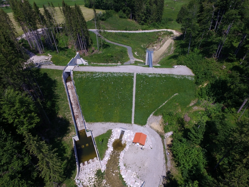
The power plants are often located at a water dam, which accumulates water at the top and then allows the water to flow out in a controlled manner.


Hydropower explained - U.S. Energy Information Administration (EIA)

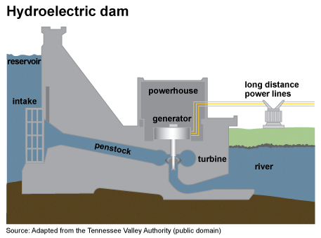
On the way down, the water flows through a turbine and then into a river.

The turbine is directly connected to a generator, which then converts the energy into electricity.

There are two different types of operation:

1.Run-of-river power plant : These can have little or no influence on the flow rate. Therefore, they are used to cover the base load of the power grid.

2.Storage power plants: Here, lakes or ponds are often used as storage. The operator of the power plant then has influence on the level of the lake or pond. This means that the production of electricity can be adjusted to the power grid. And can be increased or decreased if necessary.


Why Hydropower?

Nevertheless, the question still arises why we should use hydropower.

Where is the advantage compared to other renewable energies? Like solar power, for example?

The biggest advantage of hydropower in general is of course that it is renewable and very pure energy. Because the power plants are powered by water, there are no pollutants released into the air. Another advantage is that the power plants are local. This means that every country could in theory be self-sufficient.

In addition, the energy produced can be adapted to the energy used. Since the water is always available, energy shortages are prevented, which is also the main advantage over other renewable energies such as solar energy or wind energy. These are more difficult to control because they are not always available. Therefore, when there is a surplus, the energy must be stored for times when less is available. Hydropower can be quickly and flexibly adapted to any situation.

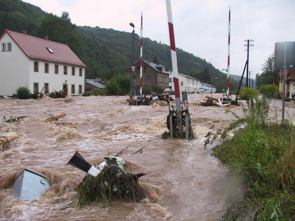
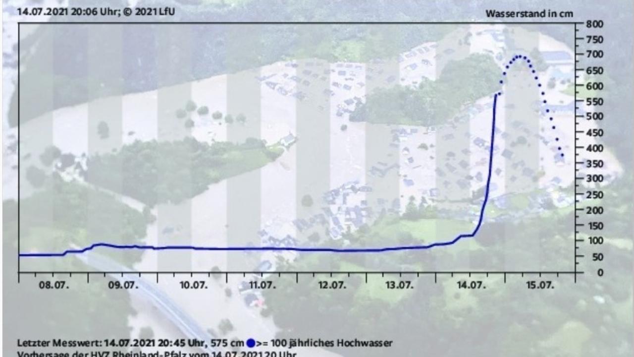
Finally, the water reservoirs serve not only for energy supply, but also for flood protection. You can read more about this here in our blog about flood protection in Germany.

Since hydro dams are no different from flood control reservoirs or dams, our applications are the same. How exactly we inspect reservoirs, you can read here. Especially with these inspections, the main concern is the safety of the divers. The water is clear enough to be inspected with the human eye. But even when the power plants are switched off, there is still strong current. This is dangerous for divers! Our drones are current resistant, or can be stabilized with an external crane.

Renewable energies bring many advantages and become more and more important, for all of us. Our drones can make a small contribution, but every contribution is important.


Do you have a hydro power plant or are you interested in our work in power plants?

Follow us on social media or contact us here!


Facebook

YouTube

LinkedIn


Thickness measurement of steel objects: How does it work?

What is a thickness gauge?

A thickness gauge is a device that can be used to quickly and easily measure the thickness of steel, e.g. ship hulls and steel sheet piles. The device is used in various sectors, such as industry, hydraulic engineering and infrastructure, but it is most commonly used to ensure that steel thickness complies with industry standards and regulations. It not only measures the thickness and density of the steel, but is also used as an additional quality assurance tool in industries such as hydraulic engineering to measure the uniformity of the steel and detect hidden damage or imperfections.


Explanation of the thickness measurement method

With the addition of the Cygnus ROV Thickness Gauge to our ROVs, inspectors can easily produce a clear report of what is happening beneath the vessel’s surface. The Cygnus Thickness Gauge is easy to mount on the ROV as the cable connects the gauge directly to the laptop. When the ROV is in the water, the pilot swims directly to the inspection site with the drone. To note the exact location of the inspection, press the nose of the thickness gauge lightly against the inspection surface.

The thickness gauge then emits various ultrasonic waves and uses these vibrations to accurately determine the thickness of the material. The gauge is very accurate: to within a tenth of a millimetre. A second operator keeps a watchful eye on the laptop and records all the data with a click. Notes can also be made if necessary. It has never been so easy to carry out inspections safely and quickly.


The Cygnus ROV thickness gauge measures metal thickness and quickly identifies areas of corrosion without removing protective layers. By emitting an echo, the gauge measures the density of the metal by measuring the delay in the return of the reverberation. To get a perceptible impression, the Cygnus thickness gauge emits multiple echoes.


The first echo determines the thickness of the protective coating. Ignoring the time delay of the protective coating for the next two echoes, the Cygnus system automatically documents the findings. With these reports, inspectors can accurately determine the integrity of the vessel and make a sound decision on a maintenance schedule.


Caviblaster

CaviBlasting is a unique and innovative method of removing fouling in a cost-effective and safe way. The technological basis of the blaster is the physics of hydrodynamic cavitation. The system generates high-energy cavitation in a controlled way. Simply put: a combination of water and small bubble implosions is sprayed onto an object with great force, removing fouling.

You can clean chains, propellers, hulls, walls and pretty much anything underwater with it. This is a safe and cost-effective alternative to using divers to clean a structure or taking the structure or vessel out of the water for cleaning.

On the Revolution ROV there is a possibility to fight against currents and the small corrections of the caviblaster. This can be done with the DVL. This is the best way to work on spot cleaning to clear metal objects of fouling. This ensures the most effective steel thickness measurement.

Continue reading “Thickness measurement of steel objects: How does it work?”

Flood protection with underwater drones?

Last week we explained the flood protection in Germany in more detail. This week we want to explain how the use of underwater drones can, theoretically, provide support in these situations.

During all the events last year, we found some uses of our drones that we think can support flood protection. In no way do we want to presume to improve or revolutionize flood protection. Nevertheless, we believe that the use of underwater drones can help in places for work relief and more efficiency.


Indirect aid from ROVS

Our drones can help especially in the area of protection against floods. This part of flood protection is preventive. Mostly, the protection consists of structural measures to hold back the water.

Of course, our drones cannot help to build these measures. But. We can help to inspect them to be sure that flood retention basins and dams are in tact.


Hochwasserrückhaltebecken - Kanton Aargau    Hochwasserrückhaltebecken - Wasserwirtschaftsamt Kempten


In the two pictures you can see an example of a flood control reservoir. Our drones can swim through the culvert and inspect all parts of the reservoir, ensuring that no cracks have occurred. For dams, the inspection works the same way. The only difference is that dams are not only used for flood control. The dam is often used for water (energy) production as well.

In addition to flood control reservoirs and dams, there are also simpler belly measures, but they still need to be inspected. The main task, however, remains the retention of water. These measures can be inspected in two groups: Dams and walls. Walls are masonry or stacked stones or concrete. Whereas dams consist of fills, which are then sealed from the outside or inside with concrete, clay or similar.


In this video we show how we inspect a concrete dam wall. With the laser scaler in the video, we measure damage directly on site. This facilitates the reperation. In addition, it is clear in this video that visibility under water is almost non-existent. Therefore, in these situations, we usually switch from the camera to the sonar. If desired, both images can also run side by side on two screens, thus creating a detailed condition survey.
Floods are becoming more likely and more severe, so it is even more important that all measures are always in good condition. With our drones, inspections can be carried out faster and more cost-effectively than an inspection with divers. As a result, more inspections and preventive inspections can be carried out. By transmitting the images live to the controller, the inspection also becomes more accurate than an inspection that must rely on the feel of the diver.

Through this indirect assistance, our drones cannot resolve emergency situations. Nevertheless, they can make work easier and indirectly contribute to the prevention of flooding.


Direct aid from ROVs

Although inspections are only an indirect way to help flood control, there are also direct ways for us to help in emergency situations.

Bestand:Hochwasser Mueglitz Schlottwitz 113-1367 IMG.JPG - Wikipedia

In this picture, you get an impression of the power of the water. The search for people, is hardly possible for divers. But as seen in the Arthal, the first missing people must be searched quickly. Our drones can help with this!

We have been supporting the search and rescue service, Signi Search Dogs, with our drones for quite some time. You can read more about it here. Especially with sonar, we don’t need visibility underwater to search for missing persons. As soon as the first currents are weakened, our drones can be easily lowered into the water from boats, bridges or other places.


This quick readiness, not only helps to get a clearer view of events underwater. Our drones can also more quickly find people who have been dragged along by the currents. In the end, lives can be saved!

For us it is important to make it clear that these capabilities are only our ideal vision. We hope to further elaborate and apply them in the following years. We want, if possible, to completely prevent or mitigate disasters like the one in Arthal. And we believe that the use of underwater drones could be a good addition to the current methods.


Continue reading “Flood protection with underwater drones?”

Flood protection in Germany

Last year we explained how the Netherlands protects itself against a flood. The reason for this was the floods that affected the Netherlands, Germany and Belgium You can read all the information about it here.

But looking back at last year and the events, we also wanted to take a closer look at flood protection in Germany. The events have also made it clear to us that we can also do our part with our drones. You can read more about how we see this happening next. First, let’s briefly explain what happened in July 2021. Then we will take a closer look at flood protection in Germany.

What happened in July 2021?

In July 2021, heavy and continuous rain broke out in the regions of Rhineland-Palatinate and North Rhine-Westphalia. This resulted in more water than the rivers could withstand. Especially the Arthal, Rhineland-Palatinate, was affected. To show how quickly everything happened, we show how the situation in the Arthal changed. The WDR (West German Broadcasting) even developed an hourly summary of the events.

On Wednesday morning, the government had already warned of heavy storms, consisting of heavy and continuous rain. The flood control centres were also informed directly. At around 11 a.m., Rhineland-Palatinate declared the second-highest risk level, red, for some areas.

Then, at 5 p.m., the state environmental agency declared the highest risk level, purple. The ‘crisis team’ was then formed. A crisis team is a meeting of experts in which the resolution of an emergency is discussed.

At 19.30, the high water level of 2021 has already exceeded the level of the 2016 flood. The State Environmental Agency also continues to adjust its water level forecast.

At 9 pm, the water level was measured for the last time. At first, it was assumed that this was due to a power failure. Later, it turned out that the house to which the measuring device was attached had been washed away.

The rain continued all night. In the picture you can see how the water level rose in one night.

Landesamt sah den Pegelstand von sieben Metern um 20 Uhr voraus – Evakuierungsaufruf erfolgte um 23.09 Uhr - Rheinland-Pfalz - Rhein-Zeitung

The effects, however, only became clear the next day. Already in the morning, 1,300 people were missing.

Arthal after the floods:


Flood protection in Germany

Many people still wonder why warnings about the floods were issued so late. Unfortunately, we can’t answer that either. Nevertheless, we asked ourselves how flood protection works in Germany and whether we could perhaps contribute to it.

However, flood protection in Germany is not generally regulated, but can be determined by each federal state itself. But there are also plans that go beyond the federal state. One example is the flood risk management plans for the Rhine catchment area. These apply to various federal states on the Rhine, but also internationally.

The general objectives of flood management are as follows (Quelle: IKRS, 2014)

Bericht zur Koordinierung der Hochwasserrisikomanagementplanung - PDF Kostenfreier Download

Prevention: In order to avoid further disasters, special care is taken to ensure that no buildings are erected in risk areas. In addition, buildings already constructed in these areas are adapted to the circumstances. The last point is the promotion of appropriate land use. Here, for example, the type of vegetation in the risk areas must be taken into account. Large plants prevent water from draining away and can lead to waterlogging.

Protection: Protection should ensure that floods are reduced in certain regions. This protection can be structural or non-structural. The best-known examples of flood protection are dams and walls. However, there are also flood retention basins to dampen the flood wave. To do this, the excess inflow is temporarily stored and slowly released again. Other construction measures include dams, which are constructed similarly to flood retention basins but can also be used to supply drinking water.

Preparedness: Preparedness refers primarily to informing the population. In the first instance, it is about informing people in affected situations about the risks and the correct behaviour.

Of course, we cannot help in all these areas. And we don’t want to presume to say that we can prevent big catastrophes like the one in July. Nevertheless, it got us thinking and we think that even small help is important, especially since floods will happen again and more often. You can read about how we want to do our part and how you can help as a private person in our blog next week.


Continue reading “Flood protection in Germany”

How our ROVs help prevent flooding

Many pipes in the Dutch water network were laid years ago. Often they are more than 30 years old. Depending on the risk involved (both financial and physical risk), inspections or replacements are scheduled. But if the risk is small, aren’t these pipes/dikes being neglected? These were constructed to move water and provide a flow without obstruction. But often an obstruction is actually found there. So what should be done with that?

High risk vs. low risk:

Most high-risk pipelines are located in residential areas where many people depend on the pipeline. Think, for example, of drinking water pipes or sewers. If these suddenly break down and stop working, many streets could be without water. There is also a risk of subsidence in a densely populated area. These pipes are therefore often well mapped out and regular maintenance or an inspection can be scheduled here.

High-risk culverts often carry a large amount of damage if something goes wrong. This usually involves bridge culverts, where the integrity of a bridge can also be at stake if the culvert fails. With a busy freeway, it cannot be the case that there is a risk here.

But pipes and culverts with relatively little risk or impact are also important to the Netherlands. Culverts are maintained by municipalities and water boards but often have a somewhat lower priority. Nevertheless, the flow through a culvert can be important.

Our findings

The video above shows that a culvert is often full of silt. When the bottom of a culvert is full of silt, the flow of water is reduced. Especially at the end of the video you can see that there is a large obstruction to be found, which in the long run can stop the flow in its entirety.

If the flow of ditches, for example, stops at a culvert, water can start to accumulate and naturally overflow the banks. This can cause roads or bicycle paths to flood and become inaccessible. This can never be the intention.

Plan of action: improve flow

Nowadays, culverts, even those with low priority, are being imaged more frequently and more quickly. Nowadays it is possible to check whether the culverts have been properly flushed and therefore whether all the sludge has been removed. After this, the culvert or pipe can be properly imaged to determine its state of service.

Also, using our sonar from Blueprint Subsea, developed a method to determine the amount of silt in pipes and culverts! This is only possible with drones equipped with sonar, because it can only be read on the sonar images. In both round and square (or rectangular) tubes we have developed methodologies that can accurately determine the amount of silt or sand on the bottom. This is crucial to determine the flow of culverts and pipes.

This method can also be seen in our video above, from 40 seconds you can see how we do this, and what the result is.
In this way it is also possible to check whether a culvert has been properly cleaned, and whether there is still a risk of flooding.
In this way, large and small floods can be prevented, and there is less chance of permanent damage!


Would you like to know more about the innovative way of measuring sludge? Or are you curious about other possibilities with our drones? Then contact us here, or follow us on one of our social media channels:

Siphon inspection and maintenance. How do we do it?

    Inspecting a siphon with an ROV, that’s possible. Easy to say of course, “but can it also be done for a siphon that hasn’t been inspected for 100 years? We would like to show what drones are capable of when used properly, and demonstrate that even these types of difficult assets that cannot be inspected traditionally can be visualised.

    What are siphons?

    When we talk about a siphon, we do not mean the siphon found under your wash basin in the bathroom. No, we mean large siphons that connect small waterways under other objects.

    To give you a general idea, we have a comparison:
    Whereas an aqueduct is used to connect water via bridges, i.e. above the ground, siphons are used to connect water under the ground.

    Why do we use siphons in practice?

    Siphons are therefore used to maintain a waterway. Often, there is an obstruction that prevents the waterway from flowing properly, and it therefore has to be diverted. This can often be done under objects, so that, for example, a stream can continue to flow between meadows, even if there is a motorway between them.

    Especially around 1900, many siphons were constructed. This was because many large canals were dug (all by hand, of course). A large canal for shipping had a higher priority than a stream, so it was logical that it would be allowed to pass through in a straight path. However, the brooklet still had influence on its surroundings, and if it were to connect to the large canal, the water of the brooklet would flow over, and it would not remain separate from the large, new canal.

    De oplossing om het beekje toch volledig intact te laten, maar de grotere prioriteit (het kanaal) voorrang te geven is dus een sifon!

    What are the latest developments in siphons?

    For maintenance, siphons have never been the biggest priority. Bridges and dykes have a greater impact on the land, so of course they take priority.

    Siphons are regularly flushed, however, in order to flush out sludge and sediment. This ensures that a siphon always has sufficient flow.

    The condition can never be determined. Many have not been checked or inspected for over 70 years, so it is not clear whether it can be safe enough to send a diver in there. Apart from that, it is not nice for a diver to dive into a pipe that goes up and down, with little room to move. This means that many siphons have never been inspected for soundness, even though this is possible nowadays…

    Inspecting a siphon with an ROV:

    Below is a possible step-by-step plan of how we envisage such an inspection with an ROV:

    Starting with lowering an ROV into the pipe and ‘just’ cruising around if possible. This way, it can be determined how much flow there is in the pipe and whether it needs to be cleaned or blown through.
    If the pipe is clean enough, a report can be made of the top and side walls by means of sonar images, to determine the quality of the siphon.

    What can go wrong with a siphon?

    A siphon can be made of different materials, such as metal or concrete. In the event that something can go wrong, for example a leak or a collapse, this is often at a connection. These are therefore always checked for soundness. There may be a crack, for example, or a rubber between the connection may no longer be in place.

    Siphons run under constructions or other waterways, and can cause subsidence if things go wrong. This under a motorway, for example, is… not convenient.

    Small problems can have major consequences, so it’s always better to look at them preventively, to make sure nothing can go wrong. With today’s technology, siphons can finally be inspected, after years of not being properly deployed. So now you can book an inspection for this, to map out the state of service, and avoid major problems.


    Would you like to know more about inspections of a siphon or other water-related assets? Then contact one of our experienced employees here!

    Or stay up to date by following us on one of our social media channels:

    Pictures say more than words…

    We have often told you what our drones are capable of. As often as possible, we also try to show pictures. This should give you an impression of the practical applications of the drone.

    This week, however, we want to show you other pictures!
    We were allowed to film in Burger’s Zoo , in Arnhem! The pictures turned out indescribable and the whole day was a pure adventure for us. We were especially happy that we were allowed to film at Burger’s Zoo, as it is known for its large aquarium. And of course these are perfect conditions for us.

    You can also watch the complete first part of our journey on YouTube.

    But in this week’s blog we want to show you our ‘behind the scenes’ pictures.

    Pictures on the coral reef

    Our first stop was the coral reef. From the outside, of course, it’s clear that it’s a zoo. But the pictures are stunning. For safety, we attached extra foam to our cable so that it would float upright. This way we could ensure that our cable does not touch the corals.

    Also, it took us a little while to balance the drone. Normally, we only operate in fresh water, where the drone floats neutrally. For salt water, however, the drone has to be made more difficult. Depending on the salt content, more or less weights have to be attached, but looking at the pictures, it was worth every effort.


    Pictures from the ray tunnel

    Our second destination was the ray tunnel. Fortunately, the drone was already balanced here, so we could start filming straight away.


    Pictures from the Tropics

    The last part of our journey took us to more tropical regions. In the ‘bush’ we had the pleasure of filming the manatees. This was more challenging than the other two tanks. The manatees were very skeptical of the drone and preferred to swim away. Nevertheless, we were able to get a few pictures of them. But in the end we focused on the fish so as not to stress the manatees unnecessarily.

    In addition, our working space was very limited, as you can see.


    After working in the tropics, we were allowed to clean our drone at the zoo’s ‘robot washing area’. Which was another first for us.


    But despite initial difficulties, the day couldn’t have gone better for us. We gained so many impressions and collected many more ideas for future collaborations.

    We would like to thank Burger’s Zoo once again for daring to test this with us! Of course, we checked with the keepers before entering each pool to see if the drone was allowed in the water. So that no animals are stressed or injured.


    Are you also looking for a way to film underwater? Or are you interested in our everyday operations?

    Contact us here.

    Or follow us on:

    A real-life story by Leo van Houwelingen, Prevent Survey BV

    Prevent Survey and H2O Drones have been good partners for a long time. But how did this cooperation come about? You can read it in this interview with Leo van Houwelingen, damage expert and co-owner of Prevent Survey BV.

    To start with, the markets of Prevent Survey and H2O Drones cross. Prevent Survey’s activities include damage assessments of ship hulls, machinery and equipment of inland navigation vessels, offshore vessels, facilities such as harbour quays, locks and bridges.
    That is where H2O Drones and Prevent Survey meet professionally. H2O Drones is specialised in underwater inspections by means of underwater drones of many of these objects.

    “We were looking for a broadening of our work, namely underwater inspections without having to go into the water ourselves,” says Leo van Houwelingen. “After some research on the internet, we almost immediately ended up with H2O Drones.” According to Van Houwelingen, underwater inspections are almost non-existent in their world. “If we do, it is done with divers,” he explains. “If we did then, it would cost a lot of money. The problem in Dutch waters is not only the visibility, which is often poor, but also the currents.” Van Houwelingen explains that divers were moved by the current, making it difficult to determine exactly where they were and what they were inspecting. “They went underwater on the left hand side and came up again starboard side. So in our industry that didn’t always work very well.”

    After some phone calls, good contact developed between H2O Drones and Prevent Survey. “We then purchased an underwater drone and designed a doppler system together with the H2O director Karst Beens”, says Van Houwelingen. With that, you can determine where the drone is underwater. “With that position, we knew which part of the ship was being inspected and could work accurately.”

    Previously, Prevent Survey’s working method was a lot different, without underwater drones. Van Houwelingen: “Before, we often had to take a ship out of the water to properly inspect the bottom. That takes a lot of time and is also quite expensive. We thought we could do it better and faster, but how?”

    “So we are now doing that with underwater drones with good success,” Van Houwelingen continues. “Even if a ship has damage underwater, it can be seen very quickly with the drones thanks to sonar. Then you don’t have to worry about the water quality either. It also broadens our market, which is very valuable. We would like to distinguish ourselves and thus deliver top quality work.”

    Van Houwelingen explains that visibility is very important in the water. H2O Drones’ underwater drones are therefore also equipped with sonar. “Without sonar you can see just a meter with a lot of rubbish in the water. Sonar doesn’t suffer from that junk, so therefore you can see a lot.” Van Houwelingen says H2O Drones helped them a lot to master this. “The cooperation was always reliable and pleasant.”

    The controls of the underwater drone were also explained by H2O Drones, says Van Houwelingen. “It is very easy to do. It is almost like a game. You shouldn’t handle it like that, of course, but it does make controlling it a lot easier.”

    Van Houwelingen says he is very satisfied with the cooperation and service of H2O Drones. “H2O Drones is always there for us. It was like that right from the start. We had some problems with the batteries, but that was solved with great attention and patience. We were more than satisfied with that: It is a reliable partner of ours.”


    Do you also want to become a customer of H2O Drones, or do you have questions about a possible cooperation in the future? Please contact us!

    Or follow us on one of our social media channels:

    How H2O Drones is making a difference in the world of underwater inspections!

    A while ago, we published a blog with malpractices in the world of underwater drones. It was mainly about purchases without service, by companies that are purely focused on sales. But new technology often turns out to be difficult to use. And how do you know beforehand what you actually need most?
    Now we explain which services H2O Drones offers, to show that not all companies are only focused on sales.

    What goes wrong when buying underwater drones?

    We call it ‘blind buying’, where a drone is bought without knowing what is best for the user. This has a few clearly distinguishable causes:

    1. Misleading information from companies
    2. A purchase purely focused on budget
    3. No service.

    Misleading information from companies:

    Many companies advertise everywhere on the website with great images of clear blue water. Nice, but in our area only found in swimming pools.
    With a good camera, there is of course a lot of visibility in these waters, but in the turbid water we have in the Netherlands, visibility is very limited. In fact, often the visibility is only one metre! Then a camera alone might not be enough.

    A purchase purely focused on budget:

    This is a sensitive point, because it is not the companies themselves that are responsible for this, but the consumers!
    If you do not know whether a drone really suits you, it is logical not to buy the most expensive one. But a drone from China that is bought at a bargain price can never be as good as a quality drone.

    Often, cheap ROVs do not last long, and the possibilities are very limited. If you are not satisfied with this (kind of) drone, it does not mean that all underwater drones are of this quality.

    Quite simply, a good price often results in poor quality.

    No service:

    Often with the cheap underwater drones, the service is also poor, if there is any service at all! For a small budget you cannot expect the best service. But often there is no service at all, especially from companies that operate abroad. Products are sold without extra information, training or help with orientation in the market.

    H2O Drones sees a gap in the market here. Literally, because these are things that should be very normal but are not happening!


    How is H2O Drones trying to fill this gap in the market?
    Services around purchasing:

    To start with, the aforementioned things do get done by H2O Drones.

    Customers are helped in a buying decision process, to see if the drone is really the right match. We don’t want to hear that an ROV is just put away because it’s not good enough. (Real tailor-made advice)
    For example, we often recommend installing a sonar on the underwater drone if it is going to be used a lot in murky water.

    After purchase we offer a standard course with theoretical and practical experience. This will enable you to actually use the drone.

    Should the ROV you have purchased not be enough? We also help as an external independent party with your inspections, if required.

    Extra possibilities offered by H2O Drones:

    Hiring is also possible! If an inspection is a one-off, or you don’t have enough time, money or expertise to purchase a drone, we will take this work off your hands. We can do this for you:

    • Independent inspection by an inspector with more than 30 years background in hydraulic engineering/water related assets.
    • Prepare a report with a clear analysis of the images taken
    • Clean your assets!
    • Provide you with advice.

    Thus, H2O Drones is not a company that wants to sell as many drones as possible, but wants to help everyone the best it can and ensure underwater safety!


    Would you like to contact us? Then click here!

    You can follow us on our social media channels:

    Hoe kan een ROV dataverwerking optimaliseren? – H2O Drones

    A ROV or underwater drone has many strengths compared to traditional inspection methods. The most important points are listed below:

    • Cost-saving
    • Safety
    • Range and visibility underwater
    • Data + data processing

    Further on in this blog you will read exactly why an underwater drone is so good at collecting data and processing it.
    Data-driven work is of great importance and will only become more important in the future.

    Collecting data with an ROV

    Data collection with an underwater drone is very easy! As soon as the drone is started up and in the water, you are already collecting data. All the images you take are automatically stored on an SD card. This includes both the camera and the sonar images.
    All additional measurements that you can see on the controller are also included and stored. You can see at what height and angle the drone is underwater, which way the drone is facing (via a compass) and how far the camera is adjusted up or down.

    This way you can always see everything exactly. By combining all the data, you get a total picture of the data, which you can use later for analyses and any follow-up steps.


    Save and review the collected data

    When your inspection is complete, you can remove the SD card from the controller and insert it into a computer or laptop. If you remove the images from the card immediately, you will be ready for the next inspection!
    As soon as the images are on your computer, you have a large amount of raw data, i.e. all the images you have made are in it.

    With all the raw data you can of course show a lot, but an inspection often revolves around a few highlights that will appear in damage reports. So you can easily edit, cut and paste the images in programs and make sure that all the highlights of the inspection are there.

    Data processing

    All data on the computer can be freely processed. All data and measurements made enable you to make a precise analysis of a possible problem and its extent. The camera images give a clear picture of what is happening to the asset underwater.
    The sonar images can also be freely edited. You can increase the playback speed, zoom in on a possible anomaly and stop the images to take a closer look.


    This is often what the sonar images look like in an analysis:

    With all these possibilities, writing a damage report or a report is easy, and you have a lot of certainty because everything is based entirely on figures and measurements.

    Don’t want to make a report because the sonar images are difficult to read? We can do that for you too! We have been analysing the images and processing them into a report for years!

    Follow-up plans and periodic inspections

    After the image analyses, you have been able to draw up a (possible) damage report, and a follow-up plan can be made.

    If repairs are necessary, they can be carried out!

    Perhaps the most important thing of all is the measurements and precise data you have obtained:
    It is perfectly possible to inspect periodically. You know exactly at what height, depth and angle the damage was during the previous inspection. You can inspect these again some time later with the same inspection. This way, you can compare the images and accurately determine what the differences are and when action is really necessary!


    Conclusion:

    With an ROV, you can obtain precise data. You can analyse and process this data, draw up reports and carry out periodic inspections from here. With the data you have acquired, everything is a lot more precise, and you can always fall back on figures and data!


    Would you like a demonstration to see how data is acquired and what it can be used for later? Then get in touch with us!

    To keep up with the latest developments, follow our social media channels: